
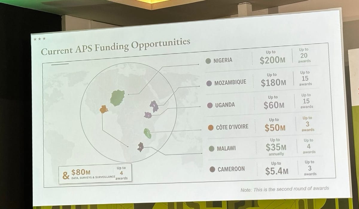
A State Department map shown at the AIDS 2026 conference in Rio de Janeiro on July 26 mislabeled every African country it depicted, misplacing Nigeria, Mozambique, and Côte d'Ivoire in entirely different regions of the continent, in front of health officials from the countries the map got wrong.
The map appeared during "Transforming Health Assistance: Implementing U.S. Government MOUs for Sustainable HIV Programs," a pre-conference session on the department's new health program agreements with African nations. NBC News identified the conference's speaker as Jeff Graham, the top U.S. health envoy who oversees PEPFAR, the President's Emergency Plan for AIDS Relief; he did not respond to requests for comment. The slide itself, photographed by attendees, listed new funding across six countries: Nigeria, Mozambique, Uganda, Côte d'Ivoire, Malawi, and Cameroon.
The map beneath that list got every one of them wrong. Nigeria, a West African nation with an Atlantic coastline, appeared landlocked deep in the Sahara. Mozambique, in southeastern Africa, was redrawn into the Horn of Africa. Côte d'Ivoire was placed on the opposite side of the continent. Uganda and Malawi landed in roughly the right neighborhood but with borders that matched neither country's actual shape, and the line for Cameroon didn't connect to any shape on the map at all.
A Reuters analysis of the image, reported by NBC News, found a watermark indicating it was generated using OpenAI's tools. OpenAI told reporters it was looking into the incident. The State Department has not said which team member built the slide or what tool they used.
A State Department spokesperson told CNN that "this was an unfortunate error caused by a team member who hastily altered the slide deck immediately before the presentation at the AIDS 2026 Conference," adding: "We take full responsibility for the confusion and misrepresentation it caused for attendees, including our African partners."
Screenshots of the slide first surfaced in a same-day Substack post by Emily Bass, an AIDS policy writer whose newsletter, "To End a Plague ... Again," tracks PEPFAR and U.S. global health policy. Bass, who attended the session, wrote that "a senior US State Department official displayed a map of Africa that was completely wrong before high-level officials from African nations, including some whose countries had been mislabelled." The images spread from there onto LinkedIn and X, with one LinkedIn post drawing roughly 40,000 views before mainstream outlets picked it up.
"Whoever created and approved this slide did not know where countries in Africa are and did not care to check their work," Matt Petit, who focuses on AI and geopolitics at the Atlantic Council, wrote in a social media post cited by both NBC News and Africanews. Cameron Hudson, a former State Department and National Security Council official who worked on Africa policy, wrote on X — as CNN reported — that the error reflects "what happens when you fire ⅓ of the State Department, eliminate multiple layers of bureaucracy and have too junior staff performing work under-supervised," adding: "There isn't just a cost savings when eviscerating staff and expertise. There's a real cost in reputation and effectiveness."
The administration has separately asked OpenAI to limit GPT-5.6's release to about 20 approved partners over security concerns, even as OpenAI has floated giving the federal government a 5% equity stake in the company.
Uristocrat reported in July on floods that killed at least 24 people in Ghana and Côte d'Ivoire — the same Côte d'Ivoire the State Department's map placed on the wrong side of the continent weeks later.
Source: NBC News, CNN, Emily Bass / Substack.



Comments